GUEST COLUMN : Joshimath crisis underlies need for a research centre for Himalayas

The parliament in 2014 had proposed a centre of Himalayan studies in Uttarakhand
 V P Dimri
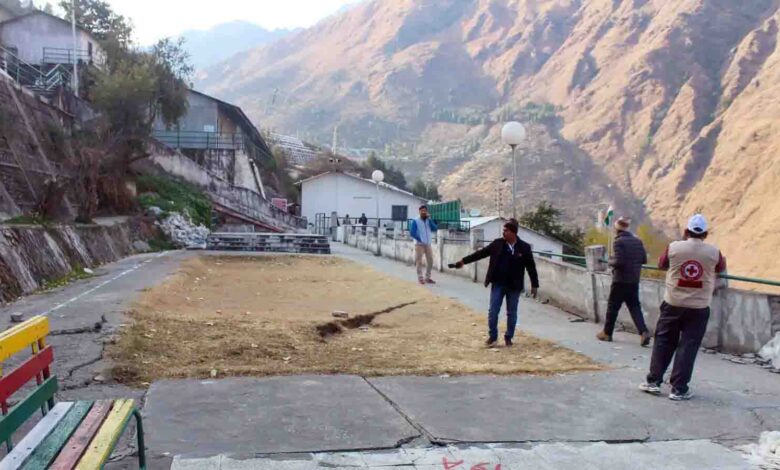
We have seen now that Joshimath in Uttarakhand is sliding and sinking. Cracks are visible on the main road and by-lanes and also in the buildings both big and small. People are being asked to leave their houses. Joshimath is a very old town in the Chamoli District of Uttarakhand. It is the gateway to the famous Badrinath temple and is a place of Adi Guru Shankaracharya. It is on the way to the valley of flowers and Hemkund Sahib. From Joshimath, there are two routes, one leads to the Mana pass while the other heads to Niti pass bordering China. Earlier it was a small town when I saw Joshimath for the first time in the summer of 1961 then the population could have been less than 500, but now the town has developed as a tourist place having many hotels, restaurants, resorts, guest houses, and new markets increasing its population by about 25,000. In addition to permanent residence, there is a flow of pilgrims and tourists who also take shelter there around the year.
Geologically Joshimath is in the Central Himalayas. Seismically the region is in seismic zone V. It is highly fragile. The town is at the high mountain (6150 feet) and below the mountain, there is a confluence of the Alaknanda and Dhauliganga rivers. The town is situated on an old glacier deposit in a landslide zone and so the topsoil is very soft. The natural drainage has been blocked due to big construction and flooded water is free to move around and sink into the ground. The drainage of the underground water system is not working satisfactorily. There is Marwadi village on the slope just below Joshimath town which is currently flooded with water. In fact, water is muddy and continuously flowing and the source of this flow of water is not known. Joshimath town is on the left bank of the Alaknanda River which is eroding the mountain. There is one long tunnel and one bypass road under construction by the NTPC for its Hydro project at Tapovan,
So, the problems of Joshimath are multi-folds. It is based on debris with the inflow of water from above and capillary upward movement of water due to rivers, fragile mountains and highly seismologically vulnerable areas. The scientific solution is based on multidisciplinary investigations such as Geological, Seismological, Geophysical, Hydrological, Glaciological, and Geotechnical which include monitoring it through space such as remote sensing and other methods.
There are many such Joshimath in the mountainous districts of Uttarakhand such as Uttarkashi, Nainital, Almora, Pithoragarh, Champawat, and others. The solution of such a diversified problem cannot be solved by one branch of science but needs a multidisciplinary approach. In fact, such an approach was proposed in the Indian Parliament in 2014 during its first budget presented by a newly elected government. The announcement was welcomed by all, particularly the people of Uttarakhand. In fact, a scientific article was published in a scientific journal current science from Bangalore with the title ” Centre for Himalayan Studies in Uttarakhand”. There could be many ways to see and solve the problem of Joshimath. These are;
1. Short-term: How to correct it?
2. Long term: How can scientifically solve it?
3. What is the ‘Way Forward’?
The short-term measure is to stop all construction work in and around Joshimath. There should be a proper drainage system and water whether rainy or any other source not to be allowed to precipitate and sink to the ground. Rather it should be diverted to the nearby stream which will flow ultimately to the river. Some chemicals can be used to increase the water-absorbing capacity of the soil. A temporary settlement for affected people should be provided by the government. There could be restrictions on the number of visitors for Joshimath. This also applies to other towns of Uttarakhand such as Badrinath and Kedarnath towns.
The long-term measure is to investigate scientifically the reasons and solutions for such conditions in Joshimath town. One should understand the geology of the town and its surrounding, Geophysics which tells us what is below Joshimath, Hydrology which gives us an idea about the source of water around Joshimath and Marwadi, Glaciology will inform us about the present scenario of debris deposited and its carrying capacity in and around Joshimath, Seismology guides for microzonation of Joshimath town which helps technocrats for the type of construction of building and roads. Meteorology speaks about rainfall and cloud bursts in the region. Similarly, geochemistry will inform us of the chemical properties of the subsurface and some chemicals can fill up the cracks in buildings and roads which are becoming a source of underground water storage. Plantation can hold the soil thus avoiding landslides.
The way forward is also short-term and long-term. The short term is immediately shifting people of Joshimath to safer places. One must agree that there are not many places where the subsurface is solid rocks, most of the places are with loose soil. So, let us find the places where the base is rocky which can be found quickly by aero geophysical surveys. One can also know by previous flood experience that there are places that have been washed out due to flood. For example, Srinagar town is on loose soil. On the other hand, the left bank of Chamoli town, which is the headquarters of Tehsil Chamoli of District Chamoli, was never affected by the flood, also during Alaknanda flood in 1970. Geophysics can be helpful in selecting such places.
The long-term way forward is a permanent solution for Uttarakhand. After the Kedarnath tragedy in June 2013, it was proposed in 2014 in Parliament that a Centre for Himalaya Study be set up in Uttarakhand. It was a welcome move of the government and a commentary was written in the leading scientific journal “Current Science, November 2014” giving details of why such an institute is necessary and how to achieve it. The proposed centre will have four divisions 1. Earth Science, 2. Climate, 3. Hydrology, 4. Environment. Earth science division would have Geology, Geophysics and Seismology. The Climate division can consist of Meteorology and Glaciology. The Hydrology division can have Water resources and Civil Construction, and the Environment can have Ecology and Biodiversity. In addition, Geographical Information Systems and Remote Sensing should be to monitor from space and the processing of huge data.
So, the government of India and Uttarakhand must reconsider the promise given to the people of Himalaya in Parliament about eight years and nine months ago after witnessing the Kedarnath tragedy for setting up a multidisciplinary Centre for Himalaya Study for the safety of the people of Himalaya.
(A Padma Shri recipient, the author is an eminent scientist who has worked in various institutions. Views expressed are personal)


