Rudraprayag- India’s most landslide-prone region

Monday, 28 August 2023 | in Guest Column
GUEST COLUMN
 MM Semwal & Arvind Singh Rawat
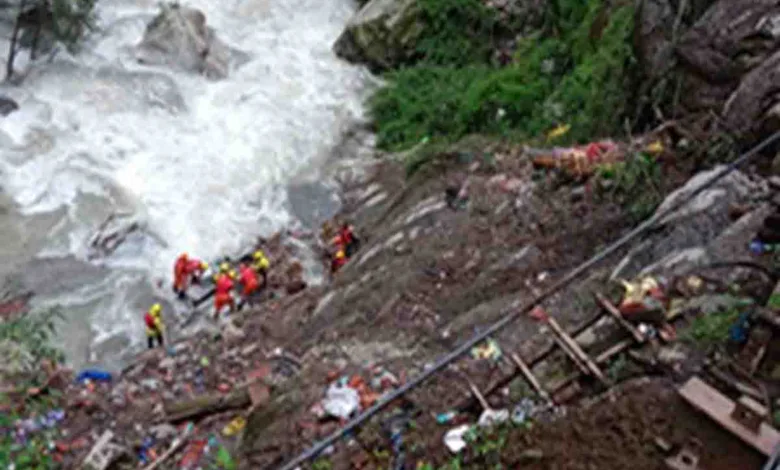
A recent study by the Indian Space Research Organisation found district Rudraprayag of Uttarakhand to be the most landslide-prone district in India. The district also has the largest landslide density and has the most exposure to the total population, working population, literacy and homes. The recent Gaurikund landslide on August 4 in which around 23 people died, has once again confirmed the report of ISRO. Being a Himalayan region, the region here is very sensitive. The tectonic compression that formed the Himalayas is responsible for their complex folding and faulting. A major fault- the Main Central Thrust (MCT) separates the Indian Plate from the overlying Eurasian Plate rocks. This is not the first time these landslide incidents have happened in Rudraprayag which has a history of landslides.
On the one hand, Rudraprayag has emerged as a Hindu religious centre with three of the Panch Kedar in the district including the most famous Kedarnath temple. On the other hand, this region has suffered considerably from disasters. Rudraprayag suffered major devastation fro an 8.0 Richter scale earthquake that struck the Garhwal region in 1804. This was followed by the 1991 earthquake and the 1998 Burwa (Ukhimath) landslide. But the real question is why the landslides are recurring. If we talk about the geological reason, we can see that Rudraprayag is on the MCT and falls under zone V of the seismic zone map of India. The region is both tectonically and seismologically fragile. This region’s weakened mountain slopes are extremely vulnerable to rain, earthquake seizures, vibrations from heavy vehicles, heavy construction and roads. The Mandakini valley was devastated by the 1991 Uttarkashi earthquake, which triggered numerous major and minor landslides and reactivated some older landslides in this region. Some major landslides of the region include-
| Landslide | Year | Casualties | Affected villages & families |
| Konthaa | 1979 | 29 | 15 villages |
| Ukhimath | 1998 | 103 | 47 villages and 1927 families |
| Phata | 2001 | 28 | 15 villages and 848 families |
| Ukhimath | 2012 | 69 | 21 villages |
Both geology and human activities have played a considerable role in triggering these landslides. Three types of landslides are observed in the region- debris slide, block slide and rock cum debris slide.
During the monsoon months, landslides and floods increase in this area. The Mangoli-Chunni village landslide in 2012 is one such incident. Back in 2012, on the night of September 14, a massive cloudburst occurred in the Rudraprayag district. The cloudburst gave way to landslides in the area, destroying houses and families that came in its way. Girish Tiwari narrates the tragic incident as he recalls that horrific night. He was 18-years-old then and at home with his parents and sister. At midnight, he recalls, a loud noise was heard and he could hear people screaming outside. Girish woke up the following day buried in debris. Nothing remained apart from debris of homes and rocks around him. He then realised the calamity had taken away his entire family and many others in his village. Girish still recalls the tragic night that took away his house, family and any other sense of belonging that he possessed. The government provided rations and money to the calamity victims as part of relief measures. But as an 18-year-old who had lost everything in the blink of an eye, Girish says it was challenging for him to get back on his feet when the government did not fulfill the promise of ensuring jobs for those struck by the tragedy. He currently runs a small shop that sells tea and instant noodles on the side of the road that connects Ukhimath and Guptkashi.
Disaster impacts children and women more mentally and physically. The women in the area still live with the fearful memories of that night. The calamity had such a major impact on the women that even today, ten years later, during the monsoon season, the women sleep with the doors wide open at night. They leave the doors open in the fear that in case the events of September 14 were to repeat themselves, the open doors would enable them to run away. In the 21st century, such fears in people’s minds seem uncalled for, but sadly they are true. The cruel reality of the tough life in the mountains, made more challenging by calamities, strikes hard when we observe their lives closely.
It has also been noticed that many families have constructed their new houses in the same location, which was devastated by the landslide. One such place is Ukhimath’s Pondar village, which was wiped out by the Bhenti-Kothi landslide in 1998. Madan Bhatt, a local resident of Burwa village says that even after facing that terrible disaster, many families have once again built houses on the disaster-affected land in the village. The reason is that most people in the village had no other option but to migrate. Due to a lack of jobs and business, they cannot bear the economic impact of being displaced. Those who had government jobs left the village. There is almost no cultivable land left in the village after the disaster. Even today, the monsoon and heavy rains remind them of the 1998 disaster. The sad thing is that these villagers fear that the mountain may crack again as in 1998. In such a situation, blasting and felling trees for big road projects seems like an invitation to disaster.
Unscientific construction of multi-storey buildings is also a major challenge in the region. Road construction and regular blasting have irreparably damaged the region’s sensitive ecosystem. Shifts in agricultural practices may also cause landslides. Identification of areas that are relatively more vulnerable to natural disasters is essential. It is recommended that buildings should not be constructed adjacent to active landslide zones. Slope stability and ground conditions must be thoroughly investigated prior to any construction. Although the government is conducting various public awareness activities, disaster management activities should be made compulsory, especially for the people of this region. Some equipment that can accurately estimate the intensity of rainfall in the area should be installed in the vulnerable areas. The majority of the district’s population works in agriculture. Despite all these major disasters, this region has a slow migration rate. One main reason is that most of the region’s population depends on the Yatra season for their livelihood. Although the government is well prepared for these tragedies, the local people also need to understand their roles and responsibilities and become smart citizens. Awareness about disaster mitigation through social media platforms can be very effective. We should remember Sunderlal Bahuguna’s words, “Ecology is a permanent economy.” After the landslide at Gaurikund, the State government said that a multi-disciplinary study of the disaster-prone areas along the Char Dham route would be done to avoid more accidents like the one at Gaurikund. Some solutions include afforestation, check dams, changing cultivation patterns and most importantly- environmental conservation. Implementing the findings of the survey on the ground is far more crucial. Otherwise, more deadly calamities will keep coming in the future, and we don’t know how many people will have to bear the pain of disaster throughout their lives.
(Semwal is head of political science department at HNB Garhwal Central University, Rawat is senior research fellow in the same department. Views expressed are personal)


