

PIONEER EDGE NEWS SERVICE/Dehradun
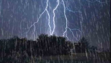
With the weather in the State fluctuating between warm and cool in the recent past, the weather is likely to get cooler in many parts of the State today. The State Meteorological Centre has issued an orange warning regarding the possibility of thunderstorms accompanied by lightning/hail/gusty winds (wind speed up to 40-50 kmph gusting to 60 kmph) likely to occur at isolated places in Dehradun, Tehri, Pauri, Nainital, Champawat and Udham Singh Nagar districts.
A yellow warning has also been issued regarding the possibility of thunderstorms accompanied by lightning/gusty winds (wind speed up to 40-50 kmph) likely to occur at isolated places in the remaining districts of the State. Apart from this, light to moderate rain/thunderstorm/snowfall (in places at altitudes of 3,000 metres and above) is likely to occur at many places in all districts of Uttarakhand. Officials further said on Tuesday that during the past 24 hours, the maximum temperatures remained markedly below normal to below normal in plains and markedly below normal in the mountainous regions of the State. The maximum temperatures are likely to fall by 4-6 degrees Celsius during the next 24 hours over many places in Uttarakhand. The maximum temperature is likely to rise gradually by 5-7 degrees Celsius during the subsequent 3-4 days over many places in Uttarakhand.
The provisional State capital Derhadun is forecast to witness a generally cloudy sky. Very light to light rain/thunderstorms accompanied with lightning/gusty wind (40-50kmph) are likely to occur here. The maximum and minimum temperatures are likely to be about 24 degrees Celsius and 12 degrees Celsius respectively in Dehradun today.